Legacy Pipeline Inspections Weren’t Designed for Scale — Until Now For decades, pipeline...
Setting a New Standard in ROW Inspections for Oil & Gas
At Xplorate, we’re excited to announce that we’ve been awarded a new right-of-way (ROW) inspection project with a major Oil & Gas operator. This marks an important step in our mission to transform how critical infrastructure is inspected and managed.
Combining Technology for Smarter Insights
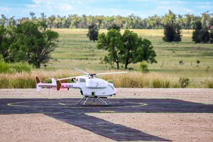
This project will see the deployment of our advanced LiDAR, RGB imaging, and proprietary 360° Vision platform, integrated with the SwissDrones SDO50 unmanned helicopter system. The SDO50 brings the endurance, payload capacity, and reliability needed to operate in challenging environments—making it a perfect fit for the scale and complexity of Oil & Gas operations.
By combining multiple sensor streams into a single immersive platform, we’re able to generate insights that go far beyond traditional inspection outputs. The result is a holistic, high-resolution digital view of infrastructure that is accurate, auditable, and immediately actionable.
Real Value for Operators
For our Oil & Gas partner, the benefits are clear:
-
Lower costs by replacing lengthy, labour-intensive ground surveys with efficient aerial inspections.
-
Faster decision-making through richer, multi-dimensional data that accelerates approvals and streamlines workflows.
-
Higher production efficiency by identifying issues before they escalate, enabling proactive asset management, and minimising downtime.
-
Improved safety and compliance with data that supports regulatory approvals and operational resilience.
The First Step in a Larger Journey
While this project is a significant milestone, it is just the beginning. With further approvals in the pipeline, we anticipate additional projects that will expand the scope of our collaboration and embed aerial intelligence deeper into our partner’s operations.
At Xplorate, we believe the future of infrastructure management lies in combining advanced data capture with intelligent analytics. This project demonstrates not only what’s possible today but also sets the stage for broader transformation across the Oil & Gas sector.
We look forward to sharing more as this partnership grows and as we continue to prove how aerial intelligence can drive safer, smarter, and more productive operations.